On a Direct Mercator chart at latitude 15°S, a certain length represents a distance of 120 NM on the Earth.The same length on the chart will represent on the Earth, at latitude 10°N, a distance of..
This question has been flagged as being in an exam by multiple students, give it more attention
A
118.2 nm
B
124.2 nm
C
122.3 nm
D
117.7 nm
Explanation
Scale Denominator = Earth Distance/Chart Distance
Let's choose an arbitrary Chart Distance of 1NM.
Scale Denominator = 120NM/1NM = 120
Now using, Scale(A)/cos(A) = Scale(B)/cos(B)
We can say 120/cos(15) = Scale(B)/cos(10) => Scale(B) = (120/cos(15)) x cos(10) = 122.3
Your Right answers are 0 out of and Your Percentage is: 0 %
Question ID: 626407
If you must descend from 15 000 ft to ground level within 17 NM, what is the necessary descent gradient?
This question has been flagged as being in an exam by multiple students, give it more attention
A
13 %
B
18 %
C
10 %
D
15 %
Explanation
Covert 15,000 ft in to NM /6080 = 2.467
2.467/17 = 0.14
0.14 X 100 = 14.51
15% is closest answer
Your Right answers are 0 out of and Your Percentage is: 0 %
Question ID: 626371
The local time at A (Longitude 049° E) is 0817 LT. The local time at Position B is 1921 LT. What is the longitude of B?
This question has been flagged as being in an exam by multiple students, give it more attention
A
117°W
B
145°W
C
117°E
D
145°E
Explanation
For an observer, the sun changes position 15°/hr.
difference in LMT = change of longitude ÷ 15
=> change of longitude = 15 x (19:21 - 08:17) = 166°
049 + 166 = 215°
360 - 215 = 145°W
Your Right answers are 0 out of and Your Percentage is: 0 %
Question ID: 626264
Given:
Conditions: ISA
Top of descent (TOD): FL130
Wind at the TOD: 280°/45 kt
Descent altitude: 1 000 ft AMSL
Wind in 1 000 ft AMSL 230°/15 kt
IAS and track during descent: 170 kt / 220°
What is your approximate ground speed (GS) during the descent?
This question has been flagged as being in an exam by multiple students, give it more attention
A
165 kt
B
214 kt
C
144 kt
D
190 kt
Explanation
Total climb = 13,000 - 1,000 = 12,000ft
We use 1/2 cruise altitude in descent.
1/2 x 12,000 = 6,000ft
Therefore we are at 6,000 + 1,000 = 7,000ft
We also need to use half the wind vector, 1/2 way between 280/45 and 230/15 => 255/30.
Now use CRP-5 to find TAS.
Use airspeed window with 7,000ft and +1°C (since this is the ISA temp at this altitude).
Find IAS 170 on the inner scale and read off TAS 189 on the outer scale.
GS = TAS ± wind, therefore we need to find the HW/TW component.
HW/TW = wind speed x cos(difference between wind direction and track) = 30 x cos(255 - 220) = 24kts HW.
This is a headwind since the value is positive, if it were negative, this would be a tailwind.
GS = 189 - 24 = 165kts
(Alternatively, you may use your CRP-5 at this point.)
Your Right answers are 0 out of and Your Percentage is: 0 %
Question ID: 626176
Given:
Magnetic track: 324°
Drift angle: 8° R
Variation:14° E
TAS:420 kts
Wind component: 30 kts (tail)
Calculate the wind (magnetic):
This question has been flagged as being in an exam by multiple students, give it more attention
A
256° / 64 kts
B
218° / 68 kts
C
084° / 68 kts
D
204° / 68 kts
Explanation
First calculate GS = 420 TAS + 30 TW = 450kts.
Now, change Magnetic Track to a Magnetic Heading, 324 - 8R Drift = 316°M
It is fine to leave both these in Magnetic since they are BOTH magnetic.
Now use CRP-5 with the above information, setting the centre grommet on TAS 420, Magnetic Heading 316 at the top.
Mark on 8R drift on GS 450.
Now rotate so that the mark is directly below the centre grommet and read off wind speed and direction at the top.
w/v = 204/68
Your Right answers are 0 out of and Your Percentage is: 0 %
Question ID: 626158
What is the average TAS climbing from an airfield at 2 000 ft up to FL290, given an airfield temperature of 20°C, a CAS 180 kt and QNH 1013?
This question has been flagged as being in an exam by multiple students, give it more attention
A
228 kt
B
289 kt
C
238 kt
D
248 kt
Explanation
In climb, we use 2/3 cruise altitude
We are actually climbing 29,000 - 2,000 = 27,000ft
2/3 x 27,000 = 18,000ft
So Pressure Altitude = 20,000ft
ISA temp @ 2000ft = +11°C
We know OAT @ 2000ft = 20°C
=> ISA + 9°C
Temp @ 20,000ft = -25 + 9 = -16°C
Use Pressure altitude 20,000ft and temp -16°X in the airspeed window on CRP-5.
Find CAS 180kts on inner scale and read off TAS 248kts on the outer scale
Your Right answers are 0 out of and Your Percentage is: 0 %
Question ID: 626150
An aircraft at position 60°00'N 005°22'W flies 165 km due East. What is the new position?
This question has been flagged as being in an exam by multiple students, give it more attention
Your Right answers are 0 out of and Your Percentage is: 0 %
Question ID: 625891
Using the following information, what is the fuel used per nautical mile of ground distance travelled?
Fuel used: 117 kilogram in 20 minutes
Groundspeed: 154 knots
This question has been flagged as being in an exam by multiple students, give it more attention
A
2.28 kg per NM
B
1.32 kg per NM
C
3.95 kg per NM
D
0.44 kg per NM
Explanation
First we want to find the fuel usage per hour. Since it's 117 kg per 20 minutes, we can multiply it by 3 to get the hourly usage. This gives us 117kg/20min = 351 kg/hr. We now need kg/NM which we can find by deviding the hourly fuel usage by the ground speed. This makes 351 kg/hr ÷ 154 NM/hr = 2.28 kg/NM.
Your Right answers are 0 out of and Your Percentage is: 0 %
Question ID: 625373
Given the following information, what is a suitable altitude for turning to the final?
Distance to the threshold: 4 NM
Threshold elevation: 700 ft
Approach angle: 3°
This question has been flagged as being in an exam by multiple students, give it more attention
A
500 ft
B
1900 ft
C
3000 ft
D
1200 ft
Explanation
3° = 5%
Climb gradient = (altitude difference/horizontal distance) x 100
=> altitude = 4 x (5/100) = 0.2NM = 1216ft
1216 + 700 = 1916ft
Your Right answers are 0 out of and Your Percentage is: 0 %
Question ID: 625351
A straight line route from A 75°S, 010°W to B is drawn on a Polar Stereographic chart with the grid aligned with the Greenwich meridian. If the true track at A is 080°, what is the grid track when passing the meridian of 050°E?
This question has been flagged as being in an exam by multiple students, give it more attention
A
090° (G)
B
110° (G)
C
330° (G)
D
070° (G)
Explanation
Grid Track = True Track ± convergency convergency = datum meridian ± local meridian = 000E/E + 010W = 010W So Grid Track = 080 - 10 = 070°G
Your Right answers are 0 out of and Your Percentage is: 0 %
Question ID: 127753
Which statement is true about small circles?
This question has been flagged as being in an exam by multiple students, give it more attention
A
The largest small circle possible has a radius which equals the Earth’s radius.
B
All rhumb lines are special cases of small circles.
C
The centre of a small circle does not coincide with the centre of the Earth.
D
The centre of each small circle is situated on the Earth’s axis.
Explanation
A small circle is any line drawn on the Earths surface which is not a great circle.
The centre of a small circle does not coincide with the centre of the Earth. -> only the centre of great circles coincides with the centre of the Earth
The centre of each small circle is situated on the Earth’s axis. -> this would be true for a great circle
The largest small circle possible has a radius which equals the Earth’s radius. -> this would be a great circle
All rhumb lines are special cases of small circles. -> the equator is an example of a rhumb line which is a great circle
Your Right answers are 0 out of and Your Percentage is: 0 %
Question ID: 124419
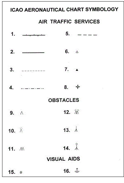
Which aeronautical chart symbol indicates a lightship?
This question has been flagged as being in an exam by multiple students, give it more attention
A
14
B
12
C
10
D
16
Explanation
1. FIR - Flight Information Region
2. ATZ - Aerodrome Traffic Zone
3. CTR - Control Zone
4. Uncontrolled Route
5. ADA - Advisory Airspace Boundary
6. Non-compulsory reporting point
7. Compulsory reporting point
8. Waypoint
9. Unlighted obstacle
10. Lighted obstacle
11. Multiple unlighted obstacles
12. Multiple lighted obstacles
13. Exceptionally high unlighted obstacle
14. Exceptionally high lighted obstacle
15. Aeronautical ground light
16. Lightship
Your Right answers are 0 out of and Your Percentage is: 0 %
Question ID: 124375
An aircraft at FL370 is required to commence descent when 100 NM from a DME facility, and to cross the station at FL120. The mean GS during the descent is 396 kt. What is approximately the minimum rate of descent required?
This question has been flagged as being in an exam by multiple students, give it more attention